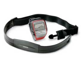
The Garmin Forerunner 305 GPS Heart Rate Monitor
Review
Mon, Jul 30, 2007 - By Spencer Ruffner
 I use a Gamin Forerunner 305 combination heart rate monitor and GPS. It comes with software although other software is available that is reported to be a little better. I just have not spent the time looking into it.
I'll describe the the graphs and information displayed from my recent Ryanman Triathlon effort on July 14 with Ryan Robinson. First, a recap of the event:
Lap 1: Swim 1.2 mile - Course was marked and accurate but my GPS distance is not accurate due to signal being lost each stroke of my arm. No heart rate as the heart rate monitor does not work under water.
- Ryan - time reported at 45 minutes
- Spencer's - time was 53:18 minutes
Lap 2: transition - time Spencer Ruffner 9.36 minutes
- Ryan waited for Spencer Ruffner and when everyone was ready.
- Then we started the bike.
Lap 3: Bike 56.9 miles - time 3 hours 13 minutes 4 seconds -3:13:04
Lap 4: transition - 8:53 minutes.
Lap 5: Run 13.6 miles - Spencer's time 2:32
- Ryan was much faster in the run. Ryan also waited for others during the partial group run.
Lap Statistics
The top section of the first image below shows statistics from the three disciplines and the transition zones in-between. As you can see, it shows a wide variety of statistics. (I think the Max Speed for the swim might be a little high...)
Lap times and zones stats
(click on image to enlarge)
Heart, Speed, and Elevation Graphs
There are 6 graph options with the Garmin software, 4 of which can be displayed at a time:
- Red: heart rate
- Dark red: % of max heart rate
- Blue: pace min / mile
- Dark blue: speed mph
- Green: elevation
- Light green: % of grade
There is also a time / distance function that changes the display parameters.
This graph below shows heart rate (red), elevation (green), and speed (blue) by Distance.
Graph with distance on the bottom axis
(click on image to enlarge)
This next graph shows heart rate (red), elevation (green), and speed (blue) by Time:
Graph with Time on the bottom axis.
(click on image to enlarge)
What ever the first selection is at the chart top left box, allows the user to display, with the movement of the mouse, any point. A readout is displayed at the point. Example: Heart rate (red) is selected then you can move the mouse to a place on the chart and read what your heart rate was at that moment. At the same time the position that you were at on the map will be highlighted.
Zones
The Garmin software lets you define three sets of zones:
- Run with a Heart Rate Zone and a Speed Zone
- Bike with a Heart Rate and a Speed Zone
- Other - If you have a sport like cross country skiing or something else- I have not used this option.
You can set up different Zones parameters for any of the Zones. The Zone can be changed by the user.
To each their own: I set my heart rate Max at 185 and the zone changes to match this maximum. Let's see 220 - 35 =185. I guess I just feel young. I do not know who came up with the formula 220 - your age = Maximum heart rate. I think it is a little light but what do I know.
The software allows you to put in birth date and weight but does not seem to change anything.
I do not change the sport during a triathlon. I just set the sport to "running" and go. I push the lap button for transitions (if I remember to do so). I push the lap button at the end of one event and again at the beginning of the next event.
I then change the sport later in the software or just drag it into the correct file folder on the computer. Changing the sport is pretty easy to do but it takes three or four screens to get it done.
My zones based on a max heart rate of 185:
| Zones for Run Heart Rate |
Beat per Minute | Percent of Max |
| 1 | 93-111 | 50 - 60% |
| 2 | 111-130 | 60-70% |
| 3 | 130-148 | 70-80% |
| 4 | 148-160 | 80-86% |
| 5 | 160-185 | 86-100% |
| Zones for Run Speed |
Minutes / Mile |
| 1 | 25-20 |
| 2 | 20-16 |
| 3 | 17-13 |
| 4 | 14-11 |
| 5 | 12-9 |
| 6 | 10-8 |
| 7 | 9-7 |
| 8 | 7-5 |
| 9 | 5-4 |
| 10 | 4-3 (I'll never in this zone unless I were to fall off a cliff!) |
| Zones for Bike Heart Rate |
Beat per Minute | Percent of Max |
| 1 | 82-98 | 44-53% |
| 2 | 98-114 | 53-62% |
| 3 | 114-130 | 62-70% |
| 4 | 130-147 | 70-79% |
| 5 | 147-163 | 79-88% |
| Zones for Bike Speed |
Miles per Hour |
| 1 | 1-4 Climb 4 |
| 2 | 4-8 Climb 3 |
| 3 | 8-12 Climb 2 |
| 4 | 12-16 Climb 1 |
| 5 | 16-20 Flat |
| 6 | 20-24 |
| 7 | 24-28 |
| 8 | 28-32 |
| 9 | 32-36 |
| 10 | 36-40 |
Summary
I like the Gamin 305, I never loose the signal. Loss of signal was a problem in dense tree cover with previous models. Support was great when I had a problem of the unit taking a surface charge and dying in a couple minutes. Gamin just replace the whole unit.
I am not happy the elevation function. It does not seam to be very accurate even when I hold the unit flat over a level course the elevation varies quite a bit.
The map overlay is great. I understand that there are other free software down loads that are better then the software that come with the device. I have to go out there and look.
Map Overlay
(click on image to enlarge)
The distance and time work extremely well. There are other neat functions such as setting a GPS point. I have input points getting the coordinates and keying them into Goggle Earth it is right there every time. (If I get the coordinates of places like Forbush Corner, I might not miss my turn when I drive up there...)
There are other functions that I have not used much: The unit can display your route on screen and even direct you back to the beginning. It will display an arrow so you can retrace your route.


